本文共 14338 字,大约阅读时间需要 47 分钟。
附近的人的位置用经纬度表示,然后通过两点的经纬度计算距离。根据网上的推荐,最终采用geohash。
geohash的实现java版:


1 importjava.util.BitSet;2 importjava.util.HashMap;3 importjava.util.Map;4
5 importorg.apache.commons.lang3.StringUtils;6
7 public classGeohash {8
9 private static int numbits = 6 * 5;10 final static char[] digits = { '0', '1', '2', '3', '4', '5', '6', '7', '8',11 '9', 'b', 'c', 'd', 'e', 'f', 'g', 'h', 'j', 'k', 'm', 'n', 'p',12 'q', 'r', 's', 't', 'u', 'v', 'w', 'x', 'y', 'z'};13
14 final static HashMap lookup = new HashMap();15 static{16 int i = 0;17 for (charc : digits)18 lookup.put(c, i++);19
20 }21
22 publicGeohash() {23 setMap();24 }25
26 public double[] decode(String geohash) {27 StringBuilder buffer = newStringBuilder();28 for (charc : geohash.toCharArray()) {29
30 int i = lookup.get(c) + 32;31 buffer.append(Integer.toString(i, 2).substring(1));32 }33
34 BitSet lonset = newBitSet();35 BitSet latset = newBitSet();36
37 //even bits
38 int j = 0;39 for (int i = 0; i < numbits * 2; i += 2) {40 boolean isSet = false;41 if (i
46 //odd bits
47 j = 0;48 for (int i = 1; i < numbits * 2; i += 2) {49 boolean isSet = false;50 if (i
55 double lon = decode(lonset, -180, 180);56 double lat = decode(latset, -90, 90);57
58 return new double[] { lat, lon };59 }60
61 private double decode(BitSet bs, double floor, doubleceiling) {62 double mid = 0;63 for (int i = 0; i < bs.length(); i++) {64 mid = (floor + ceiling) / 2;65 if(bs.get(i))66 floor =mid;67 else
68 ceiling =mid;69 }70 returnmid;71 }72
73 publicString encode(String lat, String lon) {74
75 returnencode(Double.parseDouble(lat), Double.parseDouble(lon));76
77 }78
79 public String encode(double lat, doublelon) {80 BitSet latbits = getBits(lat, -90, 90);81 BitSet lonbits = getBits(lon, -180, 180);82 StringBuilder buffer = newStringBuilder();83 for (int i = 0; i < numbits; i++) {84 buffer.append((lonbits.get(i)) ? '1' : '0');85 buffer.append((latbits.get(i)) ? '1' : '0');86 }87 return base32(Long.parseLong(buffer.toString(), 2));88 }89
90 private BitSet getBits(double lat, double floor, doubleceiling) {91 BitSet buffer = newBitSet(numbits);92 for (int i = 0; i < numbits; i++) {93 double mid = (floor + ceiling) / 2;94 if (lat >=mid) {95 buffer.set(i);96 floor =mid;97 } else{98 ceiling =mid;99 }100 }101 returnbuffer;102 }103
104 public static String base32(longi) {105 char[] buf = new char[65];106 int charPos = 64;107 boolean negative = (i < 0);108 if (!negative)109 i = -i;110 while (i <= -32) {111 buf[charPos--] = digits[(int) (-(i % 32))];112 i /= 32;113 }114 buf[charPos] = digits[(int) (-i)];115
116 if(negative)117 buf[--charPos] = '-';118 return new String(buf, charPos, (65 -charPos));119 }120
121 /*********************** 获取九个的矩形编码 ****************************************/
122 public static String BASE32 = "0123456789bcdefghjkmnpqrstuvwxyz";123 public static Map BORDERS = new HashMap();124 public static Map NEIGHBORS = new HashMap();125
126 public static voidsetMap() {127 NEIGHBORS.put("right:even", "bc01fg45238967deuvhjyznpkmstqrwx");128 NEIGHBORS.put("left:even", "238967debc01fg45kmstqrwxuvhjyznp");129 NEIGHBORS.put("top:even", "p0r21436x8zb9dcf5h7kjnmqesgutwvy");130 NEIGHBORS.put("bottom:even", "14365h7k9dcfesgujnmqp0r2twvyx8zb");131
132 NEIGHBORS.put("right:odd", "p0r21436x8zb9dcf5h7kjnmqesgutwvy");133 NEIGHBORS.put("left:odd", "14365h7k9dcfesgujnmqp0r2twvyx8zb");134 NEIGHBORS.put("top:odd", "bc01fg45238967deuvhjyznpkmstqrwx");135 NEIGHBORS.put("bottom:odd", "238967debc01fg45kmstqrwxuvhjyznp");136
137 BORDERS.put("right:even", "bcfguvyz");138 BORDERS.put("left:even", "0145hjnp");139 BORDERS.put("top:even", "prxz");140 BORDERS.put("bottom:even", "028b");141
142 BORDERS.put("right:odd", "prxz");143 BORDERS.put("left:odd", "028b");144 BORDERS.put("top:odd", "bcfguvyz");145 BORDERS.put("bottom:odd", "0145hjnp");146
147 }148
149 /**
150 * 获取九个点的矩形编码151 *152 *@paramgeohash153 *@return
154 */
155 publicString[] getGeoHashExpand(String geohash) {156 try{157 String geohashTop = calculateAdjacent(geohash, "top");158 String geohashBottom = calculateAdjacent(geohash, "bottom");159 String geohashRight = calculateAdjacent(geohash, "right");160 String geohashLeft = calculateAdjacent(geohash, "left");161 String geohashTopLeft = calculateAdjacent(geohashLeft, "top");162 String geohashTopRight = calculateAdjacent(geohashRight, "top");163 String geohashBottomRight =calculateAdjacent(geohashRight,164 "bottom");165 String geohashBottomLeft = calculateAdjacent(geohashLeft, "bottom");166 String[] expand ={ geohash, geohashTop, geohashBottom,167 geohashRight, geohashLeft, geohashTopLeft, geohashTopRight,168 geohashBottomRight, geohashBottomLeft };169 returnexpand;170 } catch(Exception e) {171 return null;172 }173 }174
175 /**
176 * 分别计算每个点的矩形编码177 *178 *@paramsrcHash179 *@paramdir180 *@return
181 */
182 public staticString calculateAdjacent(String srcHash, String dir) {183 srcHash =srcHash.toLowerCase();184 char lastChr = srcHash.charAt(srcHash.length() - 1);185 int a = srcHash.length() % 2;186 String type = (a > 0) ? "odd" : "even";187 String base = srcHash.substring(0, srcHash.length() - 1);188 if (BORDERS.get(dir + ":" + type).indexOf(lastChr) != -1) {189 base =calculateAdjacent(base, dir);190 }191 base =base192 + BASE32.toCharArray()[(NEIGHBORS.get(dir + ":" +type)193 .indexOf(lastChr))];194 returnbase;195 }196
197 //@Deprecated198 //public static void expandLngLat(String geohash, int len){199 //boolean is_even = true;200 //double[] lat = new double[3];201 //double[] lon = new double[3];202 //lat[0] = -90.0;203 //lat[1] = 90.0;204 //lon[0] = -180.0;205 //lon[1] = 180.0;206 //double lat_err = 90.0;207 //double lon_err = 180.0;208 //char[] geohashChar = geohash.toCharArray();209 // //String[] BITS = {"16", "8", "4", "2", "1"};210 //int[] BITS = {16, 8, 4, 2, 1};211 //for (int i = 0; i < geohashChar.length; i++) {212 //char c = geohashChar[i];213 //int cd = BASE32.indexOf(c);214 //for (int j = 0; j < 5; j++) {215 //int mask = BITS[j];216 //if (is_even) {217 //lon_err /= 2;218 //refine_interval(lon, cd, mask);219 //} else {220 //lat_err /= 2;221 //refine_interval(lat, cd, mask);222 //}223 //is_even = !is_even;224 //}225 //}226 //lat[2] = (lat[0] + lat[1])/2;227 // //1:[38.8970947265625, 38.902587890625, 38.89984130859375]228 // //1: 38.8970947265625, 38.902587890625, 38.89984130859375229 // //2:[38.902587890625, 38.9080810546875, 38.90533447265625]230 // //2: 38.902587890625, 38.9080810546875, 38.90533447265625231 //lon[2] = (lon[0] + lon[1])/2;232 // //1:[-77.047119140625, -77.0361328125, -77.0416259765625]233 // //1: -77.047119140625, -77.0361328125, -77.0416259765625234 // //2:[-77.047119140625, -77.0361328125, -77.0416259765625]235 // //2: -77.047119140625, -77.0361328125, -77.0416259765625236 //
237 //String topLeft = lat[0]+","+lon[0];238 //String topRight = lat[0]+","+lon[1];239 //
240 //String bottomleft = lat[1]+","+lon[0];241 //String bottoomRight = lat[1]+","+lon[1];242 //String centerPoint = (lat[0]+lat[1])/2+","+(lon[0]+lon[1])/2;243 //
244 //String centerTop = lat[0]+","+(lon[0]+lon[1])/2;245 //String centerBottom = lat[1]+","+(lon[0]+lon[1])/2;246 //
247 //String centerLeft = (lat[0]+lat[1])/2+","+lon[0];248 //String centerRight = (lat[0]+lat[1])/2+","+lon[1];249 // //System.out.println("topLeft:["+topLeft+"] geoHash:"+g.encode(lat[0],250 //lon[0]));251 // //System.out.println("topRight:["+topRight+"] geoHash:"+g.encode(lat[0],252 //lon[1]));253 // //
254 //System.out.println("bottomleft:["+bottomleft+"] geoHash:"+g.encode(lat[1],255 //lon[0]));256 // //
257 //System.out.println("bottoomRight:["+bottoomRight+"] geoHash:"+g.encode(lat[1],258 //lon[1]));259 // //
260 //System.out.println("centerPoint:["+centerPoint+"] geoHash:"+g.encode((lat[0]+lat[1])/2,261 //(lon[0]+lon[1])/2));262 // //
263 //System.out.println("centerTop:["+centerTop+"] geoHash:"+g.encode(lat[0],264 //(lon[0]+lon[1])/2));265 // //
266 //System.out.println("centerBottom:["+centerBottom+"] geoHash:"+g.encode(lat[1],267 //(lon[0]+lon[1])/2));268 // //
269 //System.out.println("centerLeft:["+centerLeft+"] geoHash:"+g.encode((lat[0]+lat[1])/2,270 //lon[0]));271 // //
272 //System.out.println("centerRight:["+centerRight+"] geoHash:"+g.encode((lat[0]+lat[1])/2,273 //lon[1]));274 //
275 //}276 //
277 //@Deprecated278 //public static void refine_interval(double[] interval, int cd, int mask){279 //if ((cd & mask)>0){280 //interval[0] = (interval[0] + interval[1])/2;281 //}else{282 //interval[1] = (interval[0] + interval[1])/2;283 //}284 //}285 //
286
287 //****************************************************************************************************************
288
289 private static final double EARTH_RADIUS = 6371;//赤道半径(单位m)
290
291 /**
292 * 转化为弧度(rad)293 **/
294 private static double rad(doubled) {295 return d * Math.PI / 180.0;296 }297
298 /**
299 * 基于googleMap中的算法得到两经纬度之间的距离,计算精度与谷歌地图的距离精度差不多,相差范围在0.2米以下300 *301 *@paramlon1302 * 第一点的精度303 *@paramlat1304 * 第一点的纬度305 *@paramlon2306 * 第二点的精度307 *@paramlat2308 * 第二点的纬度309 *@return返回的距离,单位m310 **/
311 public double getDistance(double lon1, double lat1, doublelon2,312 doublelat2) {313 double radLat1 =rad(lat1);314 double radLat2 =rad(lat2);315 double a = radLat1 -radLat2;316 double b = rad(lon1) -rad(lon2);317 double s = 2 * Math.asin(Math.sqrt(Math.pow(Math.sin(a / 2), 2)318 + Math.cos(radLat1) *Math.cos(radLat2)319 * Math.pow(Math.sin(b / 2), 2)));320 s = s *EARTH_RADIUS;321 s = Math.round(s * 1000)/1000.0;322 returns;323 }324
325 /*
326 * 永相逢超市 108.83457500177 34.256981052624 wqj6us6cmkj5bbfj6qdg s6q08ubhhuq7327 */
328 public static void main(String[] args) throwsException {329
330 //东四站 灯市口站
331 double lon1 = 116.4174628300;332 double lat1 = 39.9243669400;333 double lon2 = 116.4177739600;334 double lat2 = 39.9171260300;335 doubledist;336 String geocode;337
338 Geohash geohash = newGeohash();339 dist =geohash.getDistance(lon1, lat1, lon2, lat2);340 System.out.println("两点相距:" + dist + " km");341
342 geocode =geohash.encode(lat1, lon1);343 System.out.println("当前位置编码:" +geocode);344 double[] decode = newGeohash().decode(geocode);345 for (doubled : decode) {346 System.out.println(d);347 }348
349 geocode =geohash.encode(lat2, lon2);350 System.out.println("远方位置编码:" +geocode);351 decode = newGeohash().decode(geocode);352 for (doubled : decode) {353 System.out.println(d);354 }355
356 /*获取的geohash多少位,位数越长,精度越准*/
357 int geohashLen = 5;358
359 /*获取中心点的geohash*/
360 String code = geohash.encode(lat1, lon1).substring(0, geohashLen);361
362 /*获取所有的矩形geohash, 一共是九个 ,包含中心点,打印顺序请参考图2*/
363 String[] result =geohash.getGeoHashExpand(code);364 for(String string : result) {365 System.out.println(string);366 }367
368 }369
370 }
View Code
原理看起来很容易懂的样子,就是分区编码。但仔细一想却不是那么简单。算法设计,编码设计,为什么相似等等,现在只会痛恨当时为啥不好好学数学。
那么,只要在上传位置信息的时候计算geohash,然后根据geohash的精度前缀进行匹配查询就可以搜索附近的人。但有两个问题。
问题1:
计算的附近的概念不精准,仅仅只是一个区域,在边界问题上需要考虑。距离相近的在边界位置geohash显示却在两块区域。因此引入周围8个区域来精算中间一个区域的位置。这样做会把中间区域周围的包含,但最大范围无法估量。因为周围8块所代表的的精度算法,仅仅是该区域内的,而不是包含所有。就是说,假如中间区域精度1km以内,我需要将周围的区域加上才能把全部1km以内的位置包含。如下图所示:
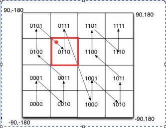
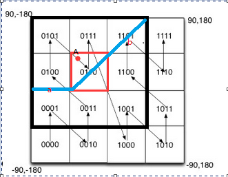
我按照0110的编码匹配,只能得到红色区域内的位置。倘若客户站在区域中心,那么正好该区域的精度就是距离客户的最大距离。但是,在其他区域的客户,比如红点。记红点为A点,A点距离最近的除了0110还包括另外三个区域的点。这样,若仅仅只按中心区域0110搜索附近的人反而不是正确的。于是引入周围8个区域的点。这样,可以把0110区域的人的附近的点全部包含。
距离:
记一个geohash的精度(区域的边长)为len,记最大距离为可以搜索到的最远的附近的位置,记最小距离为该距离内的所有位置必然包含在内。比如最小距离为d,则方圆为d的距离内的所有点都包含。
位于中心区域0110的人最大附近距离为:两个对角线b=2√2len。最小距离为:a=len
再次重申:可以肯定搜索到一个精度内的所有人,但还可以包含附近大于一个精度达部分人。
问题2:
距离需要进行2次计算。若有排序概念还需要排序。
我的抉择:
我选择了匹配前6位,测试距离大概1km以内。然后面临另一个问题:分页。
分页:
客户端滚动加载,我一次查完9个区域内所有点,然后根据时间排序。选取该时间之前的n条记录。第一页就是前n条。第一页最后一条的时间为t1,第二页就是t1时间往前的的n条,以此类推。那么,问题来了。假如第一页花费时间t,在这段时间内,本来第二页的数据位置信息更新(每次更新后时间改变);然后查询第二页的时候,变动的数据不包含在内了。也就是说,遗漏了变化的点。
在我看来,位置信息可以延时,但不要遗漏。因为喜欢查看附近的人的位置通常是实时改变的,而我们遗漏的恰恰就是互相有需求的双方。所以,要一次查询一个很大范围内的数据。
办法:
我一次将9个区域的点全部取出,然后缓存。由于geohash区域内的人共享一个查询,因此将geohash的前缀作为key来缓存该区域附近的点。那么,其他该区域的人也可以使用本次查询的结果。
用java做分页处理。
第一次请求,所有数据缓存。然后取出前n个,如果排序,则排序后的前n个。缓存信息不可以改变。第二次请求,计算缓存的索引n开始的n个。....
缺点:
我需要每次都计算距离,排序。
思考:
我想要第一次计算完之后缓存数据,然后第二次直接取出想要的部分。进而省略每次的计算。接着,问题来了。
第一次数据库的查询数据缓存,标记为key_all;客户a通过缓存计算距离,排序,放入缓存,标记为key_a;显然,两个缓存有大量的重复数据。如果仅仅是标记索引,那计算结果的部分无法保存,所以需要复制而后修改,而后存储。虽然省略了部分计算,但加大了内存需求。
对于时间和空间的问题,我们再来看需求。需求是附近的人,而我查看附近的人的翻页频率并不高,也就是说每次计算的次数很少。那我可以不用为了减少部分计算而加大存储。因为加大存储需要空间加倍,而减少计算影响不大。所以放弃每人都缓存数据。采用每次翻页时计算需要的数据。
然后,面临两个问题。
第一个:ehcache读取后的数据,被计算修改后缓存相应改变,因为对象引用相同。
然后我花了两天看反射和序列化,最后采用序列化来复制缓存对象。成功后又觉得不对,缓存显然是有序列化的,我干嘛重复加工,找到配置,copyOnRead="true" copyOnWrite="true"。解决。
第二个:排序和分页的计算方法。
客户分页的时候也会传新的位置过来,位置必然发生改变。那么按照上次分页计算的距离就不能使用了。
也就是说,我需要用户只传递一次位置,只在第一页请求的时候传递位置,往后的页码忽略其位置。因此,还需要保存第一次请求的位置。首先我要区分第一次和其他。根据现有标记无法区分,因为是按照时间排序的。所以不能区分,也就不能忽略。也就是,用户每次请求传递位置和时间。查询该位置附近该时间之前的n条记录。
finally:缓存边界
缓存是有时间限制的,如果用户第一页查询完后,第二页缓存更新,第二页就不能和第一页衔接了。
所以,为了逻辑上还是拓扑上啥的,严谨不漏。我不能接着查询第二页了。也就是读取缓存的时候,策略需要改变。若缓存不在,重新缓存数据,并查询第一页,告诉客户端刷新页面而不是请求第二页。缺点是若用户第二页是缓存结束前访问的就只能刷新,用户体验不好。所以还是不提示了?我不是产品,但严谨的态度来说,我悄悄更新?也就是第二页数据若缓存不在,我就接着查询缓存第一页作为第二页给客户端。又想多了,我不是根据页码分页的,而是根据时间分页的。那么缓存更新的时候需不需要限制时间呢。我需要按时间排序,而且需要全部数据缓存。所以不能限制时间。这样,取出新缓存的数据中,前n条,忽视时间。当缓存存在而不更新的时候才按照时间取下一组数据。客户端虽然会发现和第一页一样的数据,但时间不一样了。为了避免缓存边界的发生,我或许应该延长缓存时间。
算法遗漏:
假设默认第一次搜索是geohash匹配前6位,1km以内。设计一共2页,翻到第三页的时候就要加载更大范围内的。所以匹配前5位,这样,问题出现了。
重新匹配前5位的时候包含了之前查过的前6位的数据。
我当然可以对比数组,取消已经显示的,或者在查询匹配的时候就直接去除(比如java 8中的stream)。但这样查询语句就变的复杂。比如我的坐标是&lat=39.9346650000&lon=116.3951690000,对应的geohash是:wx4g0tukk10e。第一次匹配前6位的sql:
1 SELECT id, lat, lon, geohash, updatetime FROMuser_location2 WHERE 1=1
3 and(4 geohash like 'wx4g0t%' or geohash like 'wx4g0w%' or geohash like 'wx4g0s%'
5 or geohash like 'wx4g0v%' or geohash like 'wx4g0m%' or geohash like 'wx4g0q%'
6 or geohash like 'wx4g0y%' or geohash like 'wx4g0u%' or geohash like 'wx4g0k%')
匹配前5位并去除前6位的
1 SELECT id, lat, lon, geohash, updatetime FROMuser_location2 WHERE 1=1
3 and(4 geohash like 'wx4g0%' or geohash like 'wx4g2%' or geohash like 'wx4fb%'
5 or geohash like 'wx4g1%' or geohash like 'wx4ep%' or geohash like 'wx4er%'
6 or geohash like 'wx4g3%' or geohash like 'wx4fc%' or geohash like 'wx4dz%')7 and(8 geohash not like 'wx4g0t%' or geohash not like 'wx4g0w%' or geohash not like 'wx4g0s%'
9 or geohash not like 'wx4g0v%' or geohash not like 'wx4g0m%' or geohash not like 'wx4g0q%'
10 or geohash not like 'wx4g0y%' or geohash not like 'wx4g0u%' or geohash not like 'wx4g0k%'
11 )
View Code
这在数据层次一次性搜索增加了比较次数num*6倍。而事实上,我想做缓存的话,key=6和key=5的缓存存在被包含与包含的关系。理想的状态应该是:key=5的所有数据缓存,key=6的缓存持有key=5的缓存。这是一个对我来说复杂的缓存了。我也发现了,当我自习研究某项技术的时候什么都不会,换句话说自己就是代码搬运工而已。
现在的做法是直接缓存数据。以后升级redis了再考虑别的。
转载地址:https://blog.csdn.net/weixin_33212263/article/details/114834381 如侵犯您的版权,请留言回复原文章的地址,我们会给您删除此文章,给您带来不便请您谅解!
发表评论
最新留言
关于作者